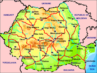
Geographical Looks of Romania
![]()
" To understand a country, one must first understand its land."
Discover the land of

![]()
"Any Hungarian or Bulgarian - and quite a lot of travellers - will tell you not to go, that it's dirty, unsafe, hell on earth, etc, etc. Don't believe it. Easy it isn't and inexperienced travellers may find it too much (hope that doesn't sound snobbish!) but Romania is a real experience. More happened there in five days than during three times as long in twee little Hungary. Romania hides nothing from you and the people are mostly friendly and curious - remember it's not long that they've been allowed to talk to foreigners, and many travellers find themselves given a bed and treated like kings."
-Andrew Warmington of Middlesex, England
![]()

Source: The 1995 Grolier Multimedia Encyclopedia
![]()
Romania: Facts in Brief |
|
| Capital: | Bucharest. |
| Official Language: | Romanian |
| Official Name: | Republica Romania (Republic of Romania). |
| Location: | Southeastern Europe, bordering the Black Sea, between Bulgaria and Ukraine |
| Geographic coordinates: | 46 00 N, 25 00 E |
| Land boundaries: | Total: 2,508 km Border countries: Bulgaria 608 km, Hungary 443 km, Moldova 450 km, Serbia and Montenegro 476 km (all with Serbia), Ukraine (north) 362 km, Ukraine (south) 169 km |
| Area: | Total area: 237,500 km2 Land area: 230,340 km2 Comparative area: slightly smaller than Oregon Greatest
distances: Border countries: Bulgaria 608 km, Hungary 443 km, Moldova 450 km, Serbia and Montenegro 476 km (all with Serbia), Ukraine (north) 362 km, Ukraine (south) 169 km |
| Maritime claims: | Contiguous zone: 24 nm Continental shelf: 200-m depth or to the depth of exploitation Exclusive economic zone: 200 nm Territorial sea: 12 nm |
| Elevation: | Highest: Mount Moldoveanu, 8,343
ft. (2,543 m) above sea level. Lowest: sea level. |
| Climate: | Temperate; cold, cloudy winters with frequent snow and fog; sunny summers with frequent showers and thunderstorms |
| Population: | Estimated 1996 population:
23,611,000. Density: 257 persons per mi2 (99 per km2). Distribution: 56 % urban, 44 % rural. 1992 census: 22,760,449. Estimated 2001 population: 24,152,000. |
| Chief Products: | Agriculture: corn, potatoes,
wheat, milk, sugar beets, grapes, wool. Manufacturing: machinery, cement, iron and steel, petroleum products, processed foods, clothing and shoes, wood products. Mining: petroleum, natural gas, coal. |
| Terrain: | Central Transylvanian Basin is separated from the
Plain of Moldavia on the east by the Carpathian Mountains and separated from the Walachian
Plain on the south by the Transylvanian Alps Lowest point: Black Sea 0 m Highest point: Moldoveanu 2,544 m |
| Natural resources: | Petroleum (reserves declining), timber, natural gas, coal, iron ore, salt |
| Land use: | Arable land: 43% Permanent crops: 3% Meadows and pastures: 19% Forest and woodland: 28% Other: 7% |
| Environment: | Current issues: soil erosion and
degradation; water pollution; air pollution in south from industrial effluents;
contamination of Danube delta wetlands Natural hazards: earthquakes most severe in south and southwest; geologic structure and climate promote landslides International agreements: party to - Air Pollution, Antarctic Treaty, Biodiversity, Climate Change, Endangered Species, Environmental Modification, Hazardous Wastes, Nuclear Test Ban, Ozone Layer Protection, Ship Pollution, Wetlands; signed, but not ratified - Antarctic-Environmental Protocol, Law of the Sea |
| Irrigated land: | 34,500 sq km (1989 est.) |
| International disputes: | Certain territory of Moldova and Ukraine - including Bessarabia and Northern Bukovina - are considered by Bucharest as historically a part of Romania; this territory was incorporated into the former Soviet Union following the Molotov-Ribbentrop Pact in 1940. |
| National Anthem: | "Desteapta-te, Romane" ("Romanian, Arise"). |
| Money: | Basic unit: leu. |
![]()

![]()